SpaceTime Arc

A data infrastructure for spatio-temporal human–environment interaction modelling — a virtual globe with a timeslider for time-traveling across the Earth’s surface.

Christian Willmes, Florian Thiery, Volker Mische

The Vision

  • A geobrowser that enables “time travel” across the Earth’s surface — navigate, visualise and analyse landscapes as they were, are, and may become.
  • Also, a well defined data model and comprehensive data basis for building spatiotemporal applications.

Systemarchitecture Overveiw

  • A (rough) high level overview of the Systemarchitecture

---
config:
  layout: elk
  look: handDrawn
  theme: neutral
---
graph TD
    A[Data Collection & Publication] --> B["Data Storage & Distribution (Server)"]
    B --> C["Applications (Clients)"]
    
    A1[Data Models] -.-> A
    A2[Data Formats] -.-> A
    A3[Publication Framework] -.-> A
    
    B1["Storage (S3 & IPFS)"] -.-> B
    B2["Matadisco"] -.-> B
    B3[LOD SematicWeb] -.-> B
    
    C1[WebApp] -.-> C
    C2[QGIS Plugin?] -.-> C
    C3[API?] -.-> C
    
    classDef tier1 stroke:#38bdf8,fill:#f0f9ff
    classDef tier2 stroke:#a78bfa,fill:#f5f3ff
    classDef tier3 stroke:#4ade80,fill:#f0fdf4
    classDef component stroke:#fb923c,fill:#fff7ed

    class A tier1
    class B tier2
    class C tier3
    class A1,A2,A3 component
    class B1,B2,B3 component
    class C1,C2,C3 component

Virtual Globe + Timeslider

  • Interactive 3D globe that is not frozen in the present — a time axis you can scrub to explore the planet’s past, present and future

  • Something like AncientEarthGlobe but also for future and much more data sources.

  • But the main product will not be geovisualization apps but integrated 4D landscapes, that can be the basis for spatiotemporal Human-Environment Interaction modellig applications, and much more.

  • It will be a data infrastructure to facilitate Integrative Geography

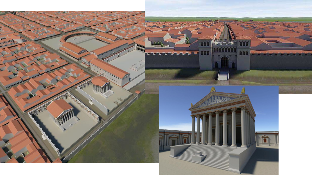
3D Geo + Time = 4D Geo

3D Model of CCAA. Source: https://nachrichten.idw-online.de/2008/10/10/virtuell-in-3-d-durch-das-roemische-koeln-flanieren-koeln-war-schon-in-der-antike-eine-grossartige-stadt

3D Geo + Time = 4D Geo
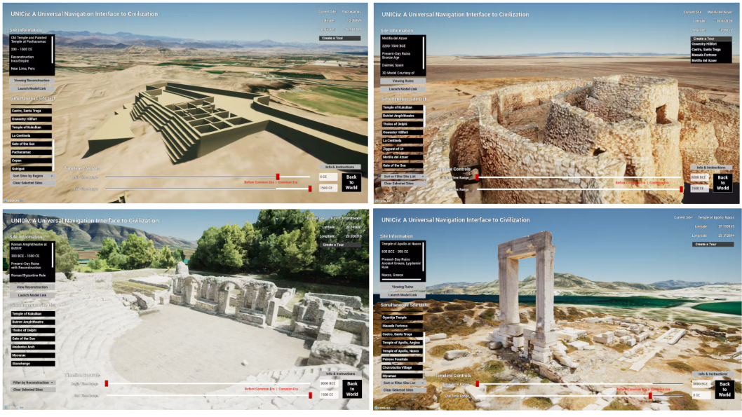
Examples of published archaeological 3D Sites in 3D Tiles format. Source: https://cesium.com/blog/2024/08/19/cesium-research-uniciv/.

Data basis: Integrated 4D landscapes

  • What kind of Environmental and Cultural data are available for past, present and future?

  • We want to compile semantically well defined spatiotemporal data sets.

  • Data gets integrated by space time context

    • Space is easy -> GIS Data formats (CNG)
    • Time is hard (heterogeneous concepts for naming time periods of the past) -> Ontology /data model

Science: Data publication

  • The 4D environmental and cultural datasets can and should be peer reviewed and published in proper venues like scientific journals, data journals and data repositories

  • These data should be published in CNG (or 3DTiles for 3D) formats

  • And published via Matadisco, so these datasets can be found form the client apps implementing our system.

Paleomaps

  • A framework to collect GIS datasets of past times to support archeological-environmental modelling.
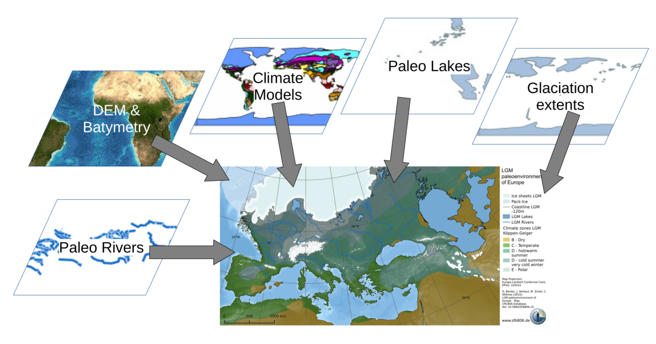
Source: Willmes (2016).

Plaeomaps: Data publication

  • The idea is to professionalise the dataset compilation and publication by submitting these datasets as data publications in peer-reviewd (data) journals.
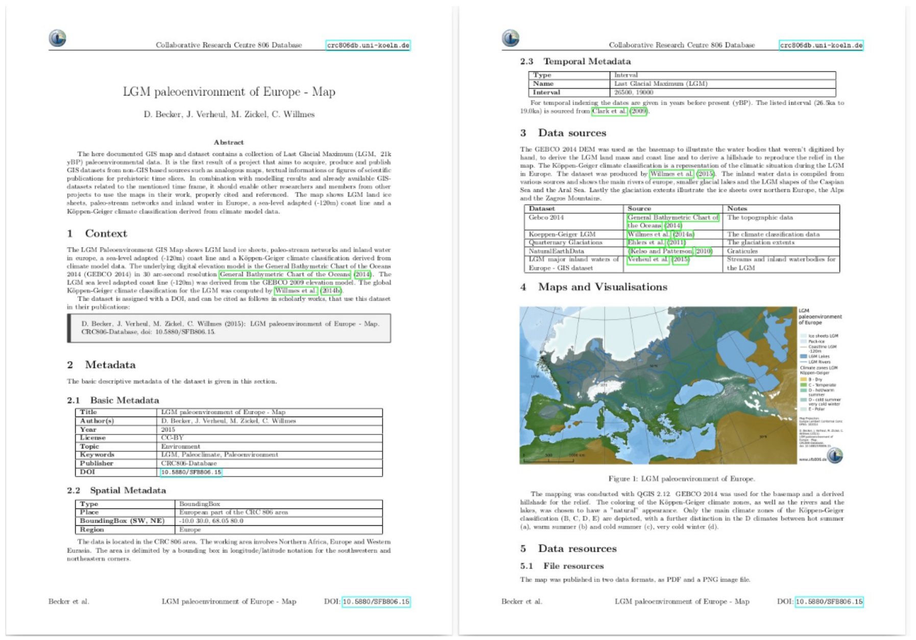
Paleomaps dataset publication.

Data: Cloud-Native Geospatial
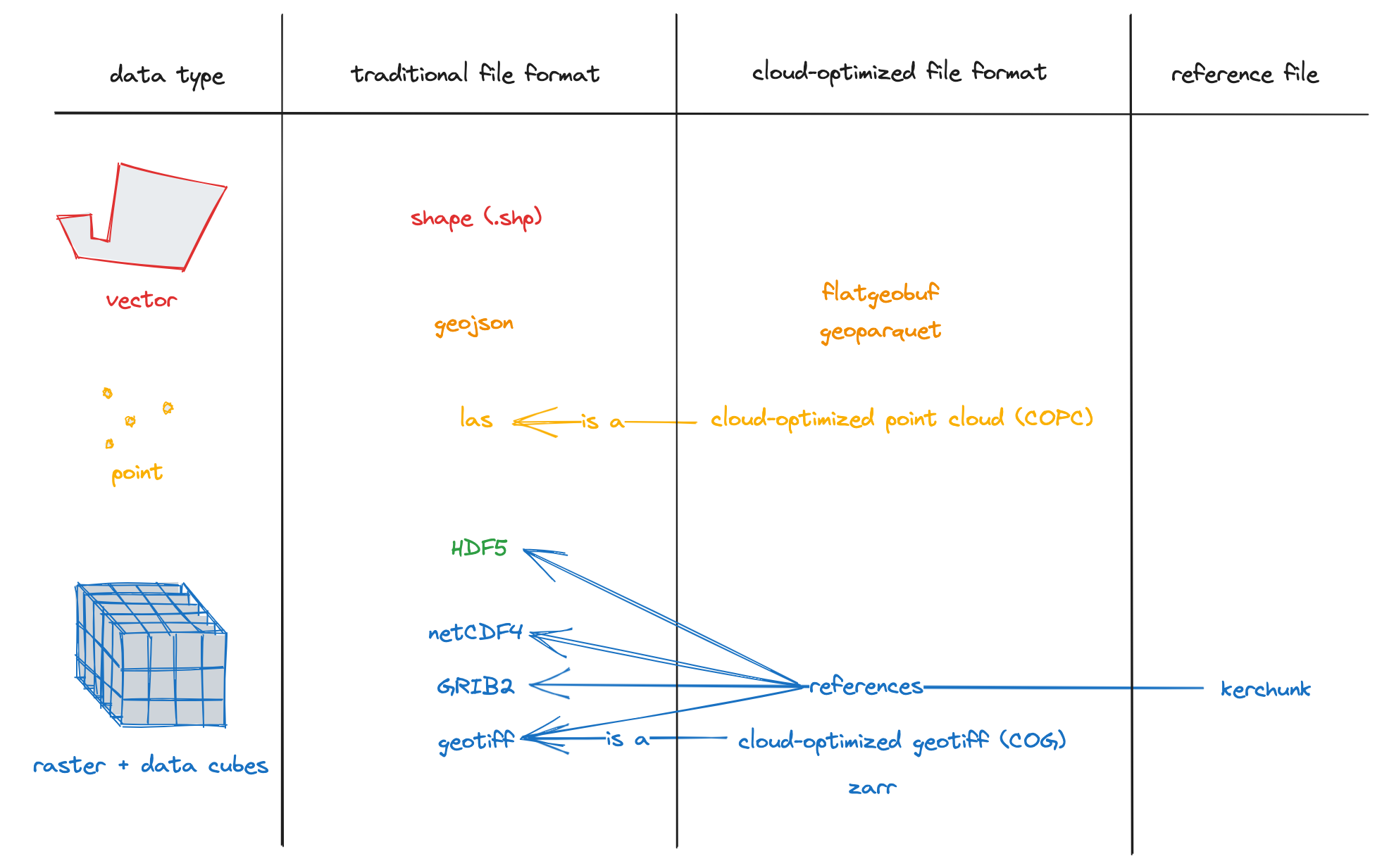
Cloud-native geospatial file formats: traditional vs. cloud-optimized formats.

Data: Semantic layer

  • Data integration based on Linked Open Data and formal data models / ontologies / terminologies
  • CIDOC CRM based geo-lod ontology: GeoScience-FAIRification-LOD
  • Temporal Data Model/Ontology like Perio.do
  • Wikidata
  • Completely reproducible by publishing the ELT code (Jupyter Notebooks)

Data: Matadisco

  • Distributed data publication and discovery
  • An open, decentralized network for data discovery. Publish metadata about any dataset to AT Protocol. Build community portals. Find what matters.
  • https://matadisco.org

It’s all about the data

  • Data infrastrucuture -> integration, access and discovery needs to be sorted/solved first.

  • In times of AI vibecoded apps, client apps are not the (main) problem anymore.

  • There is almost unlimited research potential for creating and compiling 4D landscape data sets.

  • We create a (scientific peer-reviewed) 4D model of the earth.

Comrades-In-Arms

  • We (Florian, Volker, Abhijith, Shruti, Yogiraj, Rijin and Me) need any helping hands and minds for creating this system.

  • Get in contact with us if you want to join our effort.

  • We will give a Presentaion “Systemarchitecture for networked spatio-temporal human-environment-interaction data managemet” at CHNT31 in Vienna on 11.11.

  • We will hand in an abstract for the upcomming FOSSGIS Conference in March 2027 in Heidelberg.

  • Join or keep an eye on our github organization.